[Global Hot Issue]
영국정부, 상하수도관 등 지하매설물 디지털지도 구축 2단계 프로젝트 착수
국립지하자산등록소, 전국의 건설과 개발에 혁명 일으킬 새로운 디지털 지도 프로젝트 착수
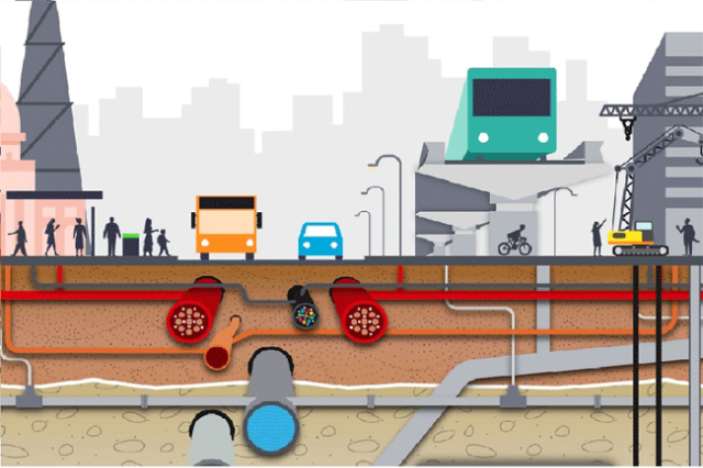
영국 정부는 건설과 개발에 혁명이 한 걸음 더 다가서면서 지하 상하수도관과 전력망(케이블), 가스관, 통신망 등의 디지털 지도 구축의 2단계를 시작했다. 영국 국립지하자산등록소(National Underground Asset Register ; NUAR)에 따르면 상하수도 배관 및 전력망, 가스관 등이 지하에 묻혀 있는 공공시설물의 디지털 지도 프로젝트 구축이 다음 단계에 접어들었다고 9월 7일 밝혔다.
이날 국무장관인 로드 트루 CBE(Lord True CBE)와 티즈 밸리(Tees Valle) 시장인 벤 호첸(Ben Houchen)은 NUAR가 해결하는데 도움이 될 현재의 난제에 대해 논의하기 위해 달링턴(Darlington)에 있는 업계 대표와 자산 소유주들을 방문했다.
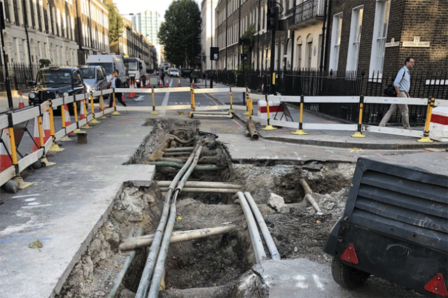
영국에서 매년 지하매설물을 찾기 위해 400만 개 이상의 구멍이 파여 있는데, 많은 구멍들이 잘못된 곳에 파여 있다. 이로 인한 공공시설물 손상의 경제적 비용은 매년 약 24억 파운드다. 이처럼 예측하지 못한 지반 상황은 특히 이전에 개발된 토지에서 모든 건설 및 주택 프로젝트에 큰 장애물이다.
지하 배관과 전력망 등의 새로운 디지털 지도는 건설과 개발의 효율성을 개선하고, 혼란을 줄이고, 근로자들의 안전을 개선하는 데 도움이 될 것이다. 이에 NUAR(국립지하자산등록소)은 가시적인 편익과 함께 더 낫고 친환경적으로 건설하고 설계에서 건설에 이르기까지 주택 및 인프라 프로젝트의 전달을 가속화하기 위한 정부 노력의 일부를 구성한다.
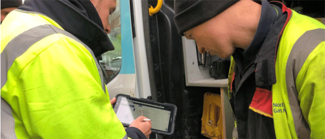
이 데이터에 대한 빠른 액세스는 유틸리티 기업 및 지방 당국의 시간과 비용을 절약하고 누출을 수정하고 새로운 인프라를 설치하려는 과정에서 발생하는 혼란을 줄일 수 있다.
국무장관인 로드 트루(Lord True) CBE는 “나는 영국의 새로운 NUAR(국립지하자산등록소)의 건설 단계를 시작하게 되어 기쁘다”라면서 “영국의 지하 유틸리티 자산에 대한 이 새로운 디지털 지도는 영국의 경제 회복의 최전선에 혁신을 두려는 우리의 헌신과 더 나은 구축을 위한 야망을 보여주는 것이다”라고 말했다.
로드 트루(Lord True) 국무장관은 이어 “이 디지털 지도는 향후 3년간 잉글랜드 북동부, 웨일스, 런던을 시작으로 산업계와 정부간 협력 하에 제작될 예정이다. 이 플랫폼을 통해 가스, 수도, 전기 및 통신과 같은 중요 및 지역 서비스가 효율적으로 유지 관리되고 현재 거리 아래에 있는 전력망, 상하수도 배관 및 덕트(duct)의 거미줄을 통해 가정과 기업에 제공될 수 있다”라고 덧붙였다.
영국 정부가 영국 북동부의 지역 파트너들과 여러 가지 프로젝트를 계속 진행함에 따라, 그것은 영국 전역에서 이용 가능한 전문지식을 활용하고 영국 평준화 의제를 구축하는데 있어서 이 지역이 하고 있는 필수적인 역할을 더욱 보여준다.
나이젤 클리포드(Nigel Clifford) 지리공간위원회 부위원장은 “지리공간 데이터에서 가치를 창출하는 것이 영국 지리공간 전략의 핵심이다. NUAR(국립지하자산등록소)는 영국에 상당한 가치가 있는 공유 국가 데이터 자산을 제공하기 위한 중요한 단계가 될 것이다. 준비 작업의 일환으로 지금까지 구축한 업계와의 협력이 자랑스럽고 앞으로도 계속되기를 기대한다”고 말했다.
벤 후첸(Ben Houchen) 티즈밸리 시장은 “나는 우리 발 밑에 있는 것에 대한 이 혁신적인 새로운 지도가 티사이드(Teesside)에서 출시되고 있다는 것에 매우 기쁘다”라면서 “이 새로운 서비스는 땅속을 팔 때 실수를 덜 하고 지역 사람들에게 혼란을 덜 준다는 것을 의미하는 것이다”라고 말했다.
티즈밸리 시장은 이어 “티사이드(Teesside), 달링턴(Darlington), 하틀풀(Hartlepool)을 넘나들며 우리는 티스웍스(Teesworks)에 있는 북유럽의 가장 큰 브라운필드를 변화시키고 있다. 우리는 수천 개의 일자리를 창출하고 우리 경제를 더 친환경적인 미래로 변화시키고 있다. 그리고 이 새로운 지도는 믿을 수 없을 정도로 도움이 될 것이다”라고 강조했다.
■ 참고 사항
1. 지리공간위원회는 이 프로그램을 제공하기 위해 웨일스 정부(Welsh government), 티즈 밸리 연합 당국(Tees Valley Combined Authority) 및 그레이터 런던 당국(Greater London Authority)과 협력할 것이다. 스코틀랜드는 이미 스코틀랜드 도로공사 등록소(Scottish Road Works Register)에서 이러한 종류의 시스템으로부터 이익을 얻고 있기 때문에, 배치는 현재 잉글랜드, 웨일즈, 북아일랜드에 계획되어 있다. 지리공간 위원회는 향후 개발에 대해 스코틀랜드 정부의 동료들과 긴밀히 협력할 것이다.
2. 지하 상하수도 배관 및 전력망의 우발적인 파업에 따른 경제적 비용은 연간 24억 파운드로 추정되며, 그 중 하나는 매몰자산 위치정보의 부정확함이다. 일단 운영되면, NUAR은 우발적인 자산 파업을 방지하고, 작업의 효율성을 향상시키며, 데이터 공유를 개선함으로써 연간 약 3억 5천만 달러의 이익을 제공할 것으로 예상된다.
3. 경쟁 조달 라운드에 이어, 지구 공간위원회는 NUAR의 건설 단계를 전달하기 위해 앳킨스(Atkins)를 임명했다. 이 단계는 잉글랜드, 웨일즈 및 런던의 북동부를 위한 최소한의 생산 가능한 제품을 구축한 다음 영국과 북 아일랜드의 나머지 지역으로 개선하고 굴리는 것으로 구성된다.

[원문보기]
Next phase of government project to map the UK’s underground pipes and cables launched
National Underground Asset Register(NUAR) is a new digital map which will revolutionise construction and development across the country.
The Government has launched the next phase in the building of a digital map of underground pipes and cables, as the country moves a step closer to revolutionising construction and development in the UK.
The National Underground Asset Register (NUAR), is now entering the Build Phase of the project. Cabinet Office Minister, Lord True CBE, and Mayor of Tees Valley, Ben Houchen, visited industry representatives and asset owners in Darlington for the launch to discuss the current challenges that NUAR will help address.
Over four million holes are dug in the UK each year, many in the wrong place. The economic cost of accidental utility damage is around £2.4 billion each year.
Unforeseen ground conditions are a major obstacle to all construction and housing projects, especially on previously developed land. The new digital map of underground pipes and cables will help improve efficiencies in construction and development, reduce disruption and improve workers’ safety.
NUAR forms part of the Government’s efforts to build back better and greener, with tangible benefits, and speed up the delivery of housing and infrastructure projects from design to build.
Fast access to this data will save utilities companies and local authorities time and money, and reduce the disruption caused in trying to fix leaks and put in new infrastructure.
Lord True CBE, Minister of State at the Cabinet Office, said : "I am delighted to launch the build phase of the UK’s new National Underground Asset Register. This new digital map of the UK’s underground utilities assets demonstrates our commitment to putting innovation at the forefront of the UK’s economic recovery and ambition to Build Back Better."
"The digital map will be built in partnership between industry and government over the next three years, starting in the North East of England, Wales and London. The platform will enable critical and local services, such as gas, water, electricity and telecommunications, to be efficiently maintained and delivered to homes and businesses via the web of cables, pipes and ducts currently beneath our streets."
"As the UK government continues to work with local partners in the North East of England on a number of projects, it further demonstrates the integral role the region is playing in utilising the expertise available in all corners of the UK and building on the nation’s levelling up agenda."
Nigel Clifford, Deputy Chair of the Geospatial Commission, said : "Unlocking value from geospatial data is the heart of the UK’s Geospatial Strategy. Our National Underground Asset Register will be a momentous step towards providing the UK with a shared national data asset of significant value. I am proud of the collaboration with industry that we have so far established as part of our preparatory work and look forward to it continuing."
Ben Houchen, Mayor of Tees Valley, said : "I am absolutely delighted that this innovative new map of what lies beneath our feet is being launched and rolled out in Teesside. This new service will mean less mistakes are made when digging holes and less disruption to local people."
"Across Teesside, Darlington and Hartlepool we’re making huge strides; we are transforming northern Europe’s biggest brownfield at Teesworks creating thousands of jobs and transforming our economy to a greener future, and this new map will be incredibly helpful."
If you have any questions about the project, and in particular if you are an owner or operator of buried assets, please get in touch via geospatialcommission@cabinetoffice.gov.uk.
Editor’s notes
1.The Geospatial Commission will be working with the Welsh government, Tees Valley Combined Authority and Greater London Authority to deliver this programme. As Scotland already benefits from a system of this kind in the Scottish Road Works Register, deployment is currently planned for England, Wales and Northern Ireland. The Geospatial Commission will continue to work closely with colleagues in the Scottish government on future developments.
2. The economic cost of accidental strikes on underground pipes and cables is estimated to be £2.4 billion per year and one cause is inaccurate information on the location of buried assets. Once operational, NUAR is expected to deliver around £350 million per year in benefits by avoiding accidental asset strikes, improving the efficiency of works and better data sharing.
3. Following a competitive procurement round, the Geospatial Commission appointed Atkins to deliver the Build Phase of NUAR. This phase consists of building a production minimal viable product for the North East of England, Wales and London, then enhancing and rolling it out to the remaining regions in England and to Northern Ireland.
[출처 = 영국정부(https://www.gov.uk/government/news/next-phase-of-government-project-to-map-the-uks-underground-pipes-and-cables-launched) / 2021년 9월 7일자 보도자료]