[미국] NASA, 우주탐사선 ‘SWOT’ 세계의 물 추적한다
미 NASA·프랑스 CNES가 공동개발 최종 시험중…SWOT, 2022년 11월 발사 예정
지구 표면수 조사·해양 표면지형 미세 부분 관찰…호수·강·바다 변화도 측정
■ NASA의 눈으로 지구 활력 징후 확인(Check Our Planet’s Vital Signs With NASA’s Eyes on the Earth)
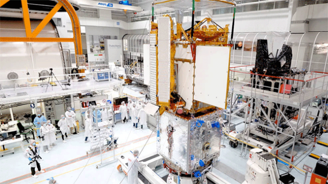
엔지니어와 기술자들로 구성된 국제팀이 지구 지표수에 대한 최초의 전세계로 탐사하고 미세 규모의 해류를 연구할 차세대 인공위성의 조립을 완료했다. SWOT(Surface Water and Ocean Topography)는 발사로부터 1년 밖에 남지 않았고, 우주선에 대한 최종 시험이 시작되었다.
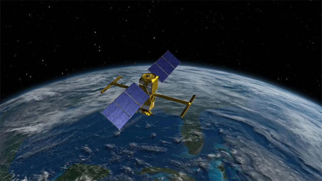
SWOT는 미국 항공우주국(NASA)과 프랑스 국립우주국(CNES)이 공동으로 개발한 우주 탐사선이다. 스포츠 실용차인 SUV(sport utility vehicle) 크기의 이 위성은 바다, 호수, 강을 포함한 지구의 염수과 담수의 높이에 대한 데이터를 수집하여 연구원들이 전 세계의 물의 양과 위치를 추적할 수 있다.
SWOT는 소용돌이치는 작은 해류가 대기의 과도한 열, 수분 및 대기의 이산화탄소와 같은 온실가스를 흡수하는 과정과 같은 기후변화가 지구의 물에 미치는 영향을 측정하는 것을 돕는다. 이 임무의 측정은 또한 해수면의 지역적 변화뿐만 아니라 행성의 호수, 강, 저수지로 얼마나 많은 물이 들어오고 나가는지를 추적하는데 도움을 줄 것이다.
워싱턴에 있는 NASA 본부의 SWOT 프로그램 과학자인 나디아 비노그라도바 시퍼(Nadya Vinogradova Shiffer)는 “SWOT는 현재 우리가 가지고 있는 모든 지표수의 세계 최초 스냅샷이 될 것”이라고 말했다.
캘리포니아 남부에 위치한 제트추진연구소(JPL ; Jet Propulsion Laboratory)의 한 팀은 이 위성의 과학적 심장을 지난 6월 프랑스 칸(Cannes)으로 보냈다. 그 이후로 그들은 CNES(프랑스 국립우주국 및 CNES의 계약자인 탈레스 알레니아 스페이스(Thales Alenia Space)의 동료들과 협력하여 과학기기를 들고 있는 우주선의 일부를 위성의 나머지 부분에 연결하고 전기 연결이 제대로 작동하는지 확인했다.
SWOT의 프로젝트 부책임자인 제트추진연구소(JPL)의 사이드 카키(Said Kaki)는 “가장 좋은 점은 서로 다른 팀이 전 세계에서 서로 구축한 두 개의 복잡한 시스템이 함께 작동하는 것을 볼 수 있다는 것”이라고 말했다.
카키(Kaki)는 JPL 소속 25명으로 구성된 초기 팀과 함께 지난 6월 이 임무의 과학장비를 따라 프랑스로 갔다. 연구팀이 직접 수행해야 할 특정 시험과 절차가 있어 SWOT 위성이 2022년 9월 미국 중부 캘리포니아 반덴버그 우주군기지(Vandenberg Space Force Base)로 발사될 때까지 미국에서 수천 마일 떨어진 이곳에서 생활하며 일하고 있다.
JPL 페이로드 시스템(JPL payload system) 엔지니어인 네이서 샤하(Nacer Chahat)는 칸(Cannes)에서 “그렇게 오랫동안 집을 떠나 있는 것이 항상 쉽지는 않지만, 다행이도 나는 놀라운 동료들에게 둘러싸여 있다”라고 말했다. 그는 현장에서 우주선 테스트를 감독하고 발생하는 모든 문제를 해결하는 데 도움을 주었다.
■ 테스트 단계(Testing Phase)
앞으로 약 6개월 동안 위성이 발사의 혹독한 환경과 우주의 혹독한 환경에서 살아남을 수 있는지 확인하기 위한 3단계 실험이 필요하다. 에진니어와 기술자들은 강렬한 진동과 발사의 덜거덕거림을 시뮬레이션하는 진동 테이블이라는 장치에 위성을 부착할 예정이다.
그런 다음 우주선은 음향실로 이동해 폭발음과 유사한 높은 데시벨 소리를 낸다. 다음으로 그들은 SWOT를 우주의 온도변화와 진공을 모방한 챔버로 옮긴다. 마지막으로, 엔지니어들은 위성의 시스템이 우주선의 다양한 부분과 다른 위성들로부터 오는 신호를 포함한 전자기파 간섭을 견딜 수 있는지 확인하기 위해 추가적인 테스트를 거친다.
SWOT의 프로젝트 부책임자인 JPL의 사이드 카키(Said Kaki)는 “그 후에, 우리는 우주선의 단추를 채우고 발사장으로 보낸다”라고 말했다. 반덴베르크에서는 2022년 11월로 예정된 발사 준비를 위해 인공위성을 마무리할 예정이다.
우주선이 궤도에 진입할 때를 대비하여 한창 진행 중이다. 과학팀 연구원들은 시뮬레이션된 데이터를 사용하여 분석 도구를 자신의 속도에 맞게 조정하고 ‘교정 및 검증(calibration and validation)’이라고 하는 출시 직후 기간을 준비한다. 이것은 과학자들이 과학기기가 데이터를 적절하게 수집하고 측정 대상을 측정하고 있는지 확인하기 위해 위성의 데이터를 지상에서 측정한 것과 비교할 때이다.
임무의 국제적 특성은 공학팀과 마찬가지로 과학팀이 여러 대륙에 걸쳐 있음을 의미한다. SWOT의 JPL 프로젝트 과학자인 리-루엥 푸(Lee-Lueng Fu)는 “임무의 프로젝트 과학자로서 제 직업의 가장 좋은 점은 해양학 및 수문학에 대한 다양한 관심과 배경을 가진 대규모 국제 연구팀과 협력할 수 있다는 것이다”라면서 “이 경험은 지구 연구에 40년 동안 헌신한 후에도 내 과학 경력의 지평을 넓혔다”라고 말했다.
■ 미션에 대한 자세한 정보(More About the Mission)
SWOT은 미국 항공우주국(NASA)과 프랑스 국립우주국(CNES)이 공동으로 개발하고 있으며 CSA와 영국우주국의 기여를 받고 있다. 캘리포니아 패서디나(Pasadena)에 있는 칼텍(Caltech)에서 NASA를 위해 관리하는 JPL은 프로젝트의 미국 구성 요소를 이끌고 있다.
비행 시스템 탑재량을 위해 NASA는 KaRIn(Ka-band Radar Interferometer) 기기, GPS 과학수신기(GPS science receiver), 레이저 역반사기( laser retroreflecto) 및 2빔 마이크로파 무선계( two-beam microwave radiometer)를 제공하고 있다.
CNES는 DORIS(도플러 궤도 위성 통합 ; Doppler Orbitography and Radioposition Integrated by Satellite) 시스템, 천저 고도계(nadir altimeter), KaRIn RF 하위 시스템(영국 우주국의 지원 포함), 플랫폼 및 지상 제어 부문을 제공하고 있다. CSA는 KarIn 고출력 송신기 조립체(high-power transmitter assembly)를 제공하고 있다. NASA는 관련 발사 서비스를 제공하고 있다.
미션에 대한 자세한 내용을 보려면 https://swot.jpl.nasa.gov/ 방문.
[원문보기]
One Year From Launch: US-European Satellite to Track World’s Water
Check Our Planet’s Vital Signs With NASA’s Eyes on the Earth
An international team of engineers and technicians has finished assembling a next-generation satellite that will make the first global survey of Earth’s surface water and study fine-scale ocean currents. The Surface Water and Ocean Topography (SWOT) mission is just a year out from launch, and the final set of tests on the spacecraft have started.
SWOT is a collaboration between NASA and the French space agency Centre National d’Etudes Spatiales (CNES), with contributions from the Canadian Space Agency (CSA) and the United Kingdom Space Agency (UK Space Agency). The SUV-size satellite will collect data on the height of Earth’s salt- and fresh water ? including oceans, lakes, and rivers ? enabling researchers to track the volume and location of water around the world.
SWOT will help to measure the effects of climate change on the planet’s water, such as the processes by which small, swirling ocean currents absorb excess heat, moisture, and greenhouse gases like carbon dioxide from the atmosphere. The mission’s measurements will also aid in following how much water flows into and out of the planet’s lakes, rivers, and reservoirs, as well as regional shifts in sea level.
“SWOT will be our first global snapshot of all surface water that we have now, how the water moves around the planet, and what happens to it in a new climate,” said Nadya Vinogradova Shiffer, SWOT program scientist at NASA Headquarters in Washington.
A team at the agency’s Jet Propulsion Laboratory in Southern California shipped the scientific heart of the satellite to Cannes, France, in June. Ever since, they’ve been working with colleagues from CNES and the French space agency’s contractor, Thales Alenia Space, to connect the part of the spacecraft holding the science instruments to the rest of the satellite and ensure that the electrical connections function properly.
“The best part has been seeing two complex systems that were built across the world from each other by different teams come together and work,” said JPL’s Said Kaki, the deputy project manager for SWOT.
Kaki, along with an initial team of about 25 people from JPL, followed the mission’s science instruments to France in June. There are certain tests and procedures that the team needs to conduct in person, so they are living and working thousands of miles from home until the SWOT satellite is shipped to its launch site at Vandenberg Space Force Base in Central California in September 2022.
“Being far away from home for so long is not always easy, but luckily, I’m surrounded by amazing coworkers,” Nacer Chahat, the JPL payload system engineer for the mission, said from Cannes. He has been onsite overseeing the spacecraft testing and helping to troubleshoot any challenges that arise.
Testing Phase
The next six months or so will involve three phases of testing to make sure the satellite will be able to survive the rigors of launch and the harsh environment of space. Engineers and technicians will attach the satellite to a device called a shake table, which simulates the intense vibrations and rattling of launch.
Then the spacecraft will move into an acoustic chamber to bombard it with high-decibel sounds similar to those of blastoff. Next, they’ll move SWOT into a chamber that mimics the temperature swings and vacuum of space. Last but not least, engineers will put the satellite through additional tests to make sure its systems can withstand any electromagnetic interference, including signals from various parts of the spacecraft and from other satellites.
“After that, we button up the spacecraft and ship it to the launch site,” said Kaki. At Vandenberg, the team will put the finishing touches on the satellite to ready it for launch, which is scheduled for no earlier than November 2022.
The mission’s science team is also in full swing, preparing for when the spacecraft is in orbit. Researchers are using simulated data to put their analytic tools through their paces, as well as prepping for the period right after launch called “calibration and validation.” This is when researchers compare data from the satellite with measurements taken on the ground in order to ensure the science instruments are collecting data properly and measuring what they’re supposed to be measuring.
The international nature of the mission means that, like the engineering team, the science team spans continents. “The best part of my job as the mission’s project scientist is being able to work with a large international research team with diverse interests and backgrounds in oceanography and hydrology,” said Lee-Lueng Fu, the JPL project scientist for SWOT. “This experience has broadened the horizon of my scientific career even after 40 years of devotion to Earth research.”
More About the Mission
SWOT is being jointly developed by NASA and CNES, with contributions from the CSA and the UK Space Agency. JPL, which is managed for NASA by Caltech in Pasadena, California, leads the U.S. component of the project. For the flight system payload, NASA is providing the Ka-band Radar Interferometer (KaRIn) instrument, a GPS science receiver, a laser retroreflector, and a two-beam microwave radiometer.
CNES is providing the Doppler Orbitography and Radioposition Integrated by Satellite (DORIS) system, nadir altimeter, the KaRIn RF subsystem (with support from the UK Space Agency), the platform, and ground control segment. CSA is providing the KaRIn high-power transmitter assembly. NASA is providing associated launch services.
To learn more about the mission, visit: https://swot.jpl.nasa.gov/
[출처 = 미국 우주항공국One Year From Launch: US-European Satellite to Track World’s Water | NASA) / 2021년 11월 18일자 보도자료]